Subpart F - West Coast Groundfish - Open Access Fisheries
Source:
75 FR 60897, Oct. 1, 2010, unless otherwise noted.
§ 660.310 Purpose and scope.
This subpart covers the Pacific Coast Groundfish open access fishery. The open access fishery, as defined at § 660.11, Subpart C, is the fishery composed of commercial vessels using open access gear fished pursuant to the harvest guidelines, quotas, and other management measures specified for the harvest of open access allocations or governing the fishing activities of open access vessels.
§ 660.311 Open access fishery—definitions.
General definitions for the Pacific Coast groundfish fisheries are defined at § 660.11, subpart C. The definitions in this subpart are specific to the open access fishery covered in this subpart and are in addition to those specified at § 660.11, subpart C.
Closely tended for the purposes of this subpart means that a vessel is within visual sighting distance or within 0.25 nm (463 m) of the gear as determined by electronic navigational equipment.
§ 660.312 Open access fishery—prohibitions.
In addition to the general prohibitions specified in §§ 660.12 and 600.725 of this chapter, it is unlawful for any person to:
(a) General.
(1) Take and retain, possess, or land groundfish in excess of the landing limit for the open access fishery without having a valid limited entry permit for the vessel affixed with a gear endorsement for the gear used to catch the fish.
(2) Black rockfish fisheries. Have onboard a commercial hook-and-line fishing vessel (other than a vessel operated by persons under § 660.60 (c)(1)(ii), subpart C), more than the amount of the trip limit set for black rockfish by § 660.330(e) while that vessel is fishing between the U.S.-Canada border and Cape Alava (48°09′30″ N. lat.), or between Destruction Island (47°40′00″ N. lat.) and Leadbetter Point (46°38′10″ N. lat.).
(3) Transport fish, if that fish includes any amount of sablefish, away from the point of landing before being sorted and weighed by federal groundfish species or species group, and recorded for submission on an electronic fish ticket under § 660.313(f). (If fish will be transported to a different location for processing, all sorting and weighing to federal groundfish species groups must occur before transporting the fish away from the point of landing).
(4) Mix fish from more than one landing, where one or more of the landings includes any amount of sablefish, prior to the fish being sorted and weighed for reporting on an electronic fish ticket under § 660.313(f).
(5) Process, sell, or discard any fish if that fish includes any amount of sablefish, that has not been accounted for on an electronic fish ticket under § 660.313(f).
(b) Recordkeeping and reporting.
(1) Fail to comply with all recordkeeping and reporting requirements at § 660.13, subpart C, including failure to submit information, or submission of inaccurate or false information on any report required at § 660.13(d), subpart C, and § 660.313.
(2) Falsify or fail to make and/or file, retain or make available any and all reports of groundfish landings that include sablefish, containing all data, and in the exact manner, required by the regulation at § 660.13, subpart C, or § 660.313.
(c) Gear.
(1) Possess, deploy, haul, or carry onboard a fishing vessel subject to this subpart a set net, trap or pot, longline, or commercial vertical hook-and-line that is not in compliance with the gear restrictions in § 660.330(b), subpart F, unless such gear is the gear of another vessel that has been retrieved at sea and made inoperable or stowed in a manner not capable of being fished. The disposal at sea of such gear is prohibited by Annex V of the International Convention for the Prevention of Pollution From Ships, 1973 (Annex V of MARPOL 73/78).
(2) Fish with dredge gear (defined in § 660.11) anywhere within EFH within the EEZ, as defined by latitude/longitude coordinates at § 660.75.
(3) Fish with beam trawl gear (defined in § 660.11) anywhere within EFH within the EEZ, as defined by latitude/longitude coordinates at § 660.75.
(4) Fish with bottom trawl gear with a footrope diameter greater than 19 inches (48 cm) (including rollers, bobbins, or other material encircling or tied along the length of the footrope) anywhere in EFH within the EEZ, as defined by latitude/longitude coordinates at § 660.75.
(d) Fishing in conservation areas with open access gears.
(1) Operate a vessel with non-groundfish trawl gear onboard in any applicable GCA (as defined at § 660.330(d)) except for purposes of continuous transiting, with all trawl gear stowed in accordance with § 660.330(b), or except as authorized in the groundfish management measures published at § 660.330.
(2) Operate a vessel in an applicable GCA (as defined at § 660.330(d) that has nontrawl gear onboard and is not registered to a limited entry permit on a trip in which the vessel is used to take and retain or possess groundfish in the EEZ, possess or land groundfish taken in the EEZ, except for purposes of continuous transiting, with all groundfish nontrawl gear stowed in accordance with § 660.330(b), or except as authorized in the groundfish management measures published at § 660.330.
(3) Fish with bottom contact gear (defined at § 660.11) within specific EFHCAs or the DECA, as specified in § 660.12(a).
(4) Fish with bottom trawl gear (defined at § 660.11) anywhere within EFH seaward of a line approximating the 700-fm (1280-m) depth contour, as defined in § 660.76. For the purposes of regulation, EFH seaward of 700-fm (1280-m) within the EEZ is described at § 660.75.
(5) Fish with bottom trawl gear (defined at § 660.11) with a footrope diameter greater than 8 inches (20 cm) (including rollers, bobbins or other material encircling or tied along the length of the footrope) anywhere within the EEZ shoreward of a line approximating the 100-fm (183-m) depth contour (defined at § 660.73).
(6) Fish with bottom trawl gear (defined at § 660.11), within the EEZ in the following EFHCAs (defined at §§ 660.77 and 660.78): Olympic 2, Biogenic 1, Biogenic 2, Quinault Canyon, Grays Canyon, Willapa Canyonhead, Willapa Deep, Biogenic 3, Astoria Deep, Astoria Canyon, Nehalem Bank/Shale Pile, Garibaldi Reef North, Garibaldi Reef South, Siletz Deepwater, Daisy Bank/Nelson Island, Newport Rockpile/Stonewall Bank, Hydrate Ridge, Heceta Bank, Deepwater off Coos Bay, Arago Reef, Bandon High Spot, Rogue Canyon, and Rogue River Reef.
(7) Fish with bottom trawl gear (defined at § 660.11), other than demersal seine, unless otherwise specified in this section or § 660.330, within the EEZ in the following EFHCAs (defined at § 660.79): Brush Patch, Trinidad Canyon, Mad River Rough Patch, Samoa Deepwater, Eel River Canyon, Blunts Reef, Mendocino Ridge, Delgada Canyon, Tolo Bank, Navarro Canyon, Point Arena North, Point Arena South Biogenic Area, The Football, Gobbler's Knob, Point Reyes Reef, Cordell Bank/Biogenic Area, Rittenburg Bank, Farallon Islands/Fanny Shoal/Cochrane Bank, Farallon Escarpment, Half Moon Bay, Pescadero Reef, Pigeon Point Reef, Ascension Canyonhead, South of Davenport, Monterey Bay/Canyon, West of Sobranes Point, Point Sur Deep, Big Sur Coast/Port San Luis, La Cruz Canyon, West of Piedras Blancas State Marine Conservation Area, East San Lucia Bank, Point Conception, Hidden Reef/Kidney Bank (within Cowcod Conservation Area West), Catalina Island, Potato Bank (within Cowcod Conservation Area West), Cherry Bank (within Cowcod Conservation Area West), Cowcod EFHCA Conservation Area East, and Southern California Bight.
[75 FR 60897, Oct. 1, 2010, as amended at 81 FR 84433, Nov. 23, 2016; 84 FR 63992, Nov. 19, 2019]
§ 660.313 Open access fishery—recordkeeping and reporting.
(a) General. General reporting requirements specified at § 660.13(a) through (c), subpart C, apply to the open access fishery.
(b) Declaration reports for vessels using nontrawl gear. Declaration reporting requirements for open access vessels using nontrawl gear (all types of open access gear other than non-groundfish trawl gear) are specified at § 660.13(d), subpart C.
(c) Declaration reports for vessels using non-groundfish trawl gear. Declaration reporting requirements for open access vessels using non-groundfish trawl gear are specified at § 660.13(d), subpart C.
(d) VMS requirements for open access fishery vessels. VMS requirements for open access fishery vessels are specified at § 660.14, subpart C.
(e) Retention of records. Any person landing groundfish must retain on board the vessel from which groundfish is landed, and provide to an authorized officer upon request, copies of any and all reports of groundfish landings containing all data, and in the exact manner, required by the applicable state law throughout the cumulative limit period during which a landing occurred and for 15 days thereafter. All relevant records used in the preparation of electronic fish ticket reports or corrections to these reports, including dock tickets, must be maintained for a period of not less than three years after the date of landing and must be immediately available upon request for inspection by NMFS or authorized officers or others as specifically authorized by NMFS.
(f) Electronic fish ticket. The first receiver, as defined at § 660.11, subpart C, of fish, if that fish includes any amount of sablefish, from an open access vessel, is responsible for compliance with all reporting requirements described in this paragraph. Per requirements at § 660.312(a), all fish, if that fish includes any amount of sablefish, must be reported via electronic fish ticket. When used in this paragraph, submit means to transmit final electronic fish ticket information via web-based form or, if a waiver is granted, by paper form. When used in this paragraph, record means the action of documenting electronic fish ticket information in any written format.
(1) Required information. All first receivers must provide the following types of information: Date of landing, vessel that made the landing, vessel identification number, name of the vessel operator, gear type used, receiver, actual weights of species landed listed by species or species group including species with no value, condition landed, number of salmon by species, number of Pacific halibut, ex-vessel value of the landing by species, fish caught inside/outside 3 miles or both, and any other information deemed necessary by the Regional Administrator (or designee) as specified on the appropriate electronic fish ticket form.
(2) Submissions. The first receiver must:
(i) Include, as part of each electronic fish ticket submission, the actual scale weight for each groundfish species as specified by requirements at § 660.15(c) and the vessel identification number. Use and maintain, for the purposes of submitting electronic fish tickets, equipment as specified at § 660.15(d).
(ii) Submit a completed electronic fish ticket no later than 24 hours after the date of landing, unless a waiver of this requirement has been granted under provisions specified at paragraph (f)(4) of this section.
(iii) If electronic fish tickets will be submitted prior to processing or transport, follow these process and submittal requirements:
(A) After completing the landing, the electronic fish ticket information must be recorded immediately.
(B) Prior to submittal of the electronic fish ticket, the information recorded for the electronic fish ticket must be reviewed by the vessel operator who delivered the fish and the port sampler, if one is present.
(C) After review, the receiver and the vessel operator must sign a printed hard copy of the electronic fish ticket or, if the landing occurs outside of business hours, the original dock ticket.
(D) Prior to submittal, three copies of the signed electronic fish ticket must be produced by the receiver and a copy provided to each of the following:
(1) The vessel operator,
(2) The state of origin if required by state regulations, and
(3) The first receiver.
(E) After review and signature, the electronic fish ticket must be submitted within 24 hours after the date of landing, as specified in paragraph (f)(2)(ii) of this section.
(iv) If electronic fish tickets will be submitted after transport, follow these process and submittal requirements:
(A) The vessel name and the electronic fish ticket number must be recorded on each dock ticket related to that landing.
(C) Upon completion of the dock ticket, but prior to transfer of the offload to another location, the dock ticket information that will be used to complete the electronic fish ticket must be reviewed by the vessel operator who delivered the fish.
(D) After review, the first receiver and the vessel operator must sign the original copy of each dock ticket related to that landing.
(E) Prior to submittal of the electronic fish ticket, three copies of the signed dock ticket must be produced by the first receiver and a copy provided to each of the following:
(1) The vessel operator,
(2) The state of origin if required by state regulations, and
(3) The first receiver.
(F) Based on the information contained in the signed dock ticket, the electronic fish ticket must be completed and submitted within 24 hours of the date of landing, as specified in paragraph (f)(2)(ii) of this section.
(G) Three copies of the electronic fish ticket must be produced by the first receiver and a copy provided to each of the following:
(1) The vessel operator,
(2) The state of origin if required by state regulations, and
(3) The first receiver.
(3) Revising a submission. In the event that a data error is found, electronic fish ticket submissions must be revised by resubmitting the revised form electronically. Electronic fish tickets are to be used for the submission of final data. Preliminary data, including estimates of fish weights or species composition, shall not be submitted on electronic fish tickets.
(4) Waivers for submission. On a case-by-case basis, a temporary written waiver of the requirement to submit electronic fish tickets may be granted by the Assistant Regional Administrator or designee if he/she determines that circumstances beyond the control of a receiver would result in inadequate data submissions using the electronic fish ticket system. The duration of the waiver will be determined on a case-by-case basis.
(5) Reporting requirements when a temporary waiver has been granted. Receivers that have been granted a temporary waiver from the requirement to submit electronic fish tickets must submit on paper the same data as is required on electronic fish tickets within 24 hours of the date of landing during the period that the waiver is in effect. Paper fish tickets must be sent by facsimile to NMFS, West Coast Region, Sustainable Fisheries Division, 206-526-6736 or by delivering it in person to 7600 Sand Point Way NE., Seattle, WA 98115. The requirements for submissions of paper tickets in this paragraph are separate from, and in addition to existing state requirements for landing receipts or fish receiving tickets.
[81 FR 84432, Nov. 23, 2016]
§ 660.316 Open access fishery—observer requirements.
(a) Observer coverage requirements —
(1) Harvesting vessels. When NMFS notifies the owner, operator, permit holder, or the manager of a harvesting vessel of any requirement to carry an observer, the harvesting vessel may not be used to fish for groundfish without carrying an observer.
(2) Processing vessels. Unless specified otherwise by the Observer Program, any vessel 125 ft (38.1 m) LOA or longer that is engaged in at-sea processing must carry two certified observers procured from a permitted observer provider, and any vessel shorter than 125 ft (38.1 m) LOA that is engaged in at-sea processing must carry one certified observer procured from a permitted observer provider, each day that the vessel is used to take, retain, receive, land, process, or transport groundfish. Owners of vessels required to carry observers under this paragraph must arrange for observer services from a permitted observer provider except when the Observer Program has determined and given notification that the vessel must carry NMFS staff or an individual authorized by NMFS in addition to or in lieu of an observer provided by a permitted observer provider.
(b) Notice of departure—basic rule. At least 24 hours (but not more than 36 hours) before departing on a fishing trip, a harvesting vessel that has been notified by NMFS that it is required to carry an observer, or that is operating in an active sampling unit, must notify NMFS (or its designated agent) of the vessel's intended time of departure. Notice will be given in a form to be specified by NMFS.
(1) Optional notice—weather delays. A harvesting vessel that anticipates a delayed departure due to weather or sea conditions may advise NMFS of the anticipated delay when providing the basic notice described in paragraph (b) of this section. If departure is delayed beyond 36 hours from the time the original notice is given, the vessel must provide an additional notice of departure not less than four hours prior to departure, in order to enable NMFS to place an observer.
(2) Optional notice—back-to-back fishing trips. A harvesting vessel that intends to make back-to-back fishing trips (i.e., trips with less than 24 hours between offloading from one trip and beginning another), may provide the basic notice described in paragraph (b) of this section for both trips, prior to making the first trip. A vessel that has given such notice is not required to give additional notice of the second trip.
(c) Cease fishing report. Within 24 hours of ceasing the taking and retaining of groundfish, vessel owners, operators, or managers must notify NMFS or its designated agent that fishing has ceased. This requirement applies to any harvesting or processing vessel that is required to carry an observer, or that is operating in a segment of the fleet that NMFS has identified as an active sampling unit.
(d) Waiver. The West Coast Regional Administrator (or designate) may provide written notification to the vessel owner stating that a determination has been made to temporarily waive coverage requirements because of circumstances that are deemed to be beyond the vessel's control.
(e) Vessel responsibilities —
(1) Accommodations and food. An operator of a vessel required to carry one or more observer(s) must provide accommodations and food that are Equivalent to those provided to the crew.
(2) Safe conditions. Maintain safe conditions on the vessel for the protection of observer(s) including adherence to all USCG and other applicable rules, regulations, or statutes pertaining to safe operation of the vessel, and provisions at §§ 600.725 and 600.746 of this chapter. Have on board a valid Commercial Fishing Vessel Safety Decal that certifies compliance with regulations found in 33 CFR chapter I and 46 CFR chapter I, a certificate of compliance issued pursuant to 46 CFR 28.710 or a valid certificate of inspection pursuant to 46 U.S.C. 3311.
(3) Observer communications. Facilitate observer communications by:
(i) Observer use of equipment. Allowing observer(s) to use the vessel's communication equipment and personnel, on request, for the entry, transmission, and receipt of work-related messages, at no cost to the observer(s), observer provider or NMFS.
(ii) Functional equipment. Ensuring that the vessel's communications equipment, used by observers to enter and transmit data, is fully functional and operational.
(4) Vessel position. Allow observer(s) access to, and the use of, the vessel's navigation equipment and personnel, on request, to determine the vessel's position.
(5) Access. Allow observer(s) free and unobstructed access to the vessel's bridge, trawl or working decks, holding bins, processing areas, freezer spaces, weight scales, cargo holds, and any other space that may be used to hold, process, weigh, or store fish or fish products at any time.
(6) Prior notification. Notify observer(s) at least 15 minutes before fish are brought on board, or fish and fish products are transferred from the vessel, to allow sampling the catch or observing the transfer, unless the observer specifically requests not to be notified.
(7) Records. Allow observer(s) to inspect and copy any state or Federal logbook maintained voluntarily or as required by regulation.
(8) Assistance. Provide all other reasonable assistance to enable observer(s) to carry out their duties, including, but not limited to:
(i) Measuring decks, codends, and holding bins.
(ii) Providing the observer(s) with a safe work area.
(iii) Collecting bycatch when requested by the observer(s).
(iv) Collecting and carrying baskets of fish when requested by the observer(s).
(v) Allowing the observer(s) to collect biological data and samples.
(vi) Providing adequate space for storage of biological samples.
(f) Observer sampling station. This paragraph contains the requirements for observer sampling stations. The vessel owner must provide an observer sampling station that complies with this section so that the observer can carry out required duties.
(1) Accessibility. The observer sampling station must be available to the observer at all times.
(2) Location. The observer sampling station must be located within four meters of the location from which the observer samples unsorted catch. Unobstructed passage must be provided between the observer sampling station and the location where the observer collects sample catch.
[75 FR 60897, Oct. 1, 2010, as amended at 77 FR 55158, Sept. 7, 2012; 78 FR 68773, Nov. 15, 2013; 80 FR 22301, Apr. 21, 2015]
§ 660.319 Open access fishery gear identification and marking.
(a) Gear identification.
(1) Open access fixed gear (longline, trap or pot, set net and stationary hook-and-line gear, including commercial vertical hook-and-line gear) must be marked at the surface and at each terminal end, with a pole, flag, light, radar reflector, and a buoy.
(2) Open access commercial vertical hook-and-line gear that is closely tended as defined at § 660.311 of this subpart, may be marked only with a single buoy of sufficient size to float the gear.
(3) A buoy used to mark fixed gear under paragraph (a)(1) or (a)(2) of this section must be marked with a number clearly identifying the owner or operator of the vessel. The number may be either:
(i) If required by applicable state law, the vessel's number, the commercial fishing license number, or buoy brand number; or
(ii) The vessel documentation number issued by the USCG, or, for an undocumented vessel, the vessel registration number issued by the state.
(b) [Reserved]
§ 660.320 Open access fishery—crossover provisions.
The crossover provisions listed at § 660.60(h)(7), apply to vessels fishing in the open access fishery.
[76 FR 74747, Dec. 1, 2011]
§ 660.330 Open access fishery - management measures.
(a) General. Groundfish species taken in open access fisheries will be managed with cumulative trip limits (see trip limits in Tables 3 (North) and 3 (South) of this subpart), size limits (see § 660.60(h)(5)), seasons (see seasons in Tables 3 (North) and 3 (South) of this subpart), gear restrictions (see paragraph (b) of this section), and closed areas (see paragraph (d) of this section and §§ 660.70 through 660.79). Unless otherwise specified, a vessel operating in the open access fishery is subject to, and must not exceed any trip limit, frequency limit, and/or size limit for the open access fishery. Cowcod retention is prohibited in all fisheries and groundfish vessels operating south of Point Conception must adhere to CCA restrictions (see paragraph (d)(11) of this section and § 660.70). Retention of yelloweye rockfish is prohibited in all open access fisheries. For information on the open access daily/weekly trip limit fishery for sablefish, see § 660.332 of this subpart and the trip limits in Tables 3 (North) and 3 (South) of this subpart. Open access vessels are subject to daily or weekly sablefish limits in addition to cumulative limits for each cumulative limit period. Only one sablefish landing per week may be made in excess of the daily trip limit and, if the vessel chooses to make a landing in excess of that daily trip limit, then that is the only sablefish landing permitted for that week. The trip limit for black rockfish caught with hook-and-line gear also applies, see paragraph (e) of this section. Open access vessels that fish with non-groundfish trawl gear or in the salmon troll fishery north of 40°10′ N lat. are subject the cumulative limits and closed areas (except the pink shrimp fishery which is not subject to RCA restrictions) listed in Tables 3 (North) and 3 (South) of this subpart. Federal commercial groundfish regulations are not intended to supersede any more restrictive state commercial groundfish regulations relating to federally managed groundfish.
(b) Gear restrictions. Open access gear includes longline, trap, pot, hook-and-line (fixed or mobile), setnet (anchored gillnet or trammel net, which are permissible south of 38° N. lat. only), spear and non-groundfish trawl gear (trawls used to target non-groundfish species: pink shrimp or ridgeback prawns, and, south of Pt. Arena, CA (38°57.50' N. lat.), California halibut or sea cucumbers). Restrictions for gears used in the open access fisheries are as follows:
(1) Non-groundfish trawl gear. Non-groundfish trawl gear is generally trawl gear used to target pink shrimp, ridgeback prawn, California halibut and sea cucumber and is exempt from the limited entry trawl gear restrictions at § 660.130(b). The following gear restrictions apply to non-groundfish trawl gear:
(i) Bottom trawl gear with a footrope diameter greater than 19 inches (48 cm) (including rollers, bobbins, or other material encircling or tied along the length of the footrope) is prohibited anywhere in EFH within the EEZ, as defined by latitude/longitude coordinates at § 660.75. unless such gear is the gear of another vessel that has been retrieved at sea and made inoperable or stowed in a manner not capable of being fished. The disposal at sea of such gear is prohibited by Annex V of the International Convention for the Prevention of Pollution From Ships, 1973 (Annex V of MARPOL 73/78).
(ii) [Reserved]
(2) Fixed gear.
(i) Fixed gear (longline, trap or pot, set net and stationary hook-and-line gear, including commercial vertical hook-and-line gear) must be attended at least once every 7 days. Vessels fishing with bottom longline and snap gears as defined at § 660.11 are subject to the requirements of the Seabird Avoidance Program described in § 660.21.
(ii) Set nets. Fishing for groundfish with set nets is prohibited in the fishery management area north of 38°00.00' N. lat.
(iii) Traps or pots. Traps must have biodegradable escape panels constructed with 21 or smaller untreated cotton twine in such a manner that an opening at least 8 inches (20.3 cm) in diameter results when the twine deteriorates.
(iv) Spears. Spears may be propelled by hand or by mechanical means.
(c) Sorting requirements.
(1) In addition to the requirements at § 660.12(a)(8) the States of Washington, Oregon, and California may also require that vessels record their landings as sorted on their state landing receipts.
(2) For open access vessels, the following species must be sorted:
(i) Coastwide - widow rockfish, canary rockfish, darkblotched rockfish, yelloweye rockfish, shortbelly rockfish, black rockfish, blue/deacon rockfish, minor nearshore rockfish, minor shelf rockfish, minor slope rockfish, shortraker rockfish, rougheye/blackspotted rockfish, shortspine and longspine thornyhead, Dover sole, arrowtooth flounder, petrale sole, starry flounder, English sole, other flatfish, lingcod, sablefish, Pacific cod, spiny dogfish, longnose skate, other fish, Pacific whiting, big skate, and Pacific sanddabs;
(ii) North of 40°10′ N. lat. - POP, yellowtail rockfish, cabezon (California), Washington cabezon/kelp greenling complex, Oregon cabezon/kelp greenling complex; and
(iii) South of 40°10′ N. lat. - minor shallow nearshore rockfish, minor deeper nearshore rockfish, chilipepper, bocaccio, splitnose rockfish, cowcod, bronzespotted rockfish, blackgill rockfish and cabezon.
(d) Groundfish conservation areas (GCAs). GCAs, a type of closed area, are defined at § 660.11 and with latitude and longitude coordinates at §§ 660.70 through 660.74. A vessel that is authorized by this paragraph to fish within a GCA (e.g., fishing for “other flatfish” using hook and line gear only), may not simultaneously have other gear on board the vessel that is unlawful to use for fishing within the GCA. The following GCAs apply to vessels participating in the open access groundfish fishery.
(1) North coast recreational yelloweye rockfish conservation area. The latitude and longitude coordinates of the North Coast Recreational Yelloweye Rockfish Conservation Area (YRCA) boundaries are specified at § 660.70, subpart C. The North Coast Recreational YRCA is designated as an area to be avoided (a voluntary closure) by commercial fixed gear fishers.
(2) North coast commercial yelloweye rockfish conservation area. The latitude and longitude coordinates of the North Coast Commercial Yelloweye Rockfish Conservation Area (YRCA) boundaries are specified at § 660.70, subpart C. Fishing with open access gear is prohibited within the North Coast Commercial YRCA. It is unlawful to take and retain, possess, or land groundfish taken with open access gear within the North Coast Commercial YRCA. Open access vessels may transit through the North Coast Commercial YRCA with or without groundfish on board.
(3) South coast recreational yelloweye rockfish conservation area. The latitude and longitude coordinates of the South Coast Recreational Yelloweye Rockfish Conservation Area (YRCA) boundaries are specified at § 660.70, subpart C. The South Coast Recreational YRCA is designated as an area to be avoided (a voluntary closure) by commercial fixed gear fishers.
(4) Westport offshore recreational YRCA. The latitude and longitude coordinates that define the Westport Offshore Recreational YRCA boundaries are specified at § 660.70, subpart C. The Westport Offshore Recreational YRCA is designated as an area to be avoided (a voluntary closure) by commercial fixed gear fishers.
(5) Point St. George YRCA. The latitude and longitude coordinates of the Point St. George YRCA boundaries are specified at § 660.70, subpart C. Fishing with open access gear is prohibited within the Point St. George YRCA, on dates when the closure is in effect. It is unlawful to take and retain, possess, or land groundfish taken with open access gear within the Point St. George YRCA, on dates when the closure is in effect. The closure is not in effect at this time. This closure may be imposed through inseason adjustment. Open access vessels may transit through the Point St. George YRCA, at any time, with or without groundfish on board.
(6) South Reef YRCA. The latitude and longitude coordinates of the South Reef YRCA boundaries are specified at § 660.70, subpart C. Fishing with open access gear is prohibited within the South Reef YRCA, on dates when the closure is in effect. It is unlawful to take and retain, possess, or land groundfish taken with open access gear within the South Reef YRCA, on dates when the closure is in effect. The closure is not in effect at this time. This closure may be imposed through inseason adjustment. Open access gear vessels may transit through the South Reef YRCA, at any time, with or without groundfish on board.
(7) Reading Rock YRCA. The latitude and longitude coordinates of the Reading Rock YRCA boundaries are specified at § 660.70, subpart C. Fishing with open access gear is prohibited within the Reading Rock YRCA, on dates when the closure is in effect. It is unlawful to take and retain, possess, or land groundfish taken with open access gear within the Reading Rock YRCA, on dates when the closure is in effect. The closure is not in effect at this time. This closure may be imposed through inseason adjustment. Open access gear vessels may transit through the Reading Rock YRCA, at any time, with or without groundfish on board.
(8) Point Delgada (North) YRCA. The latitude and longitude coordinates of the Point Delgada (North) YRCA boundaries are specified at § 660.70, subpart C. Fishing with open access gear is prohibited within the Point Delgada (North) YRCA, on dates when the closure is in effect. It is unlawful to take and retain, possess, or land groundfish taken with open access gear within the Point Delgada (North) YRCA, on dates when the closure is in effect. The closure is not in effect at this time. This closure may be imposed through inseason adjustment. Open access gear vessels may transit through the Point Delgada (North) YRCA, at any time, with or without groundfish on board.
(9) Point Delgada (South) YRCA. The latitude and longitude coordinates of the Point Delgada (South) YRCA boundaries are specified at § 660.70, subpart C. Fishing with open access gear is prohibited within the Point Delgada (South) YRCA, on dates when the closure is in effect. It is unlawful to take and retain, possess, or land groundfish taken with open access gear within the Point Delgada (South) YRCA, on dates when the closure is in effect. The closure is not in effect at this time. This closure may be imposed through inseason adjustment. Open access gear vessels may transit through the Point Delgada (South) YRCA, at any time, with or without groundfish on board.
(10) Salmon Troll Yelloweye Rockfish Conservation Area (YRCA). The latitude and longitude coordinates of the Salmon Troll YRCA boundaries are specified in the groundfish regulations at § 660.70, subpart C, and in the salmon regulations at § 660.405. Fishing with salmon troll gear is prohibited within the Salmon Troll YRCA. It is unlawful for commercial salmon troll vessels to take and retain, possess, or land fish taken with salmon troll gear within the Salmon Troll YRCA. Open access vessels may transit through the Salmon Troll YRCA with or without fish on board.
(11) Cowcod Conservation Areas (CCAs). It is unlawful to take and retain, possess, or land groundfish within the CCAs, except for species authorized in this paragraph caught according to gear requirements in this paragraph, when those waters are open to fishing. Commercial fishing vessels may transit through the Western CCA with their gear stowed and groundfish on board only in the transit corridor, defined at § 660.70. Fishing with open access gear is prohibited in the CCAs, except as follows:
(i) Fishing for “other flatfish” is allowed within the CCAs with hook and line gear only; and provided a valid declaration report as required at § 660.13(d), has been filed with NMFS OLE.
(ii) Fishing for rockfish and lingcod is permitted shoreward of the boundary line approximating the 40 fm (73 m) depth contour within the CCAs when trip limits authorize such fishing and provided a valid declaration report as required at § 660.13(d) has been filed with NMFS OLE. Coordinates for the boundary line approximating the 40 fm (73 m) depth contour are listed in § 660.71.
(12) Nontrawl rockfish conservation areas for the open access fisheries. The nontrawl RCAs are closed areas, defined by specific latitude and longitude coordinates (specified at §§ 660.70 through 660.74, subpart C) designed to approximate specific depth contours, where fishing for groundfish with nontrawl gear is prohibited. Boundaries for the nontrawl RCA throughout the year are provided in the open access trip limit tables, Table 3 (North) and Table 3 (South) of this subpart and may be modified by NMFS inseason pursuant to § 660.60(c).
(i) It is unlawful to operate a vessel in the nontrawl RCA that has nontrawl gear onboard and is not registered to a limited entry permit on a trip in which the vessel is used to take and retain or possess groundfish in the EEZ, or land groundfish taken in the EEZ, except for the purpose of continuous transiting, or when the use of nontrawl gear is authorized in part 660.
(ii) On any trip on which a groundfish species is taken with nontrawl open access gear and retained, the open access nontrawl vessel may transit through the nontrawl RCA only if all groundfish nontrawl gear is stowed either: Below deck; or if the gear cannot readily be moved, in a secured and covered manner, detached from all lines, so that it is rendered unusable for fishing.
(iii) The nontrawl RCA restrictions in this section apply to vessels taking and retaining or possessing groundfish in the EEZ, or landing groundfish taken in the EEZ. Unless otherwise authorized by part 660, a vessel may not retain any groundfish taken on a fishing trip for species other than groundfish that occurs within the nontrawl RCA. If a vessel fishes in a non-groundfish fishery in the nontrawl RCA, it may not participate in any fishing for groundfish on that trip that is prohibited within the nontrawl RCA. [For example, if a vessel fishes in the salmon troll fishery within the RCA, the vessel cannot on the same trip fish in the sablefish fishery outside of the RCA.]
(iv) Fishing for “other flatfish” off California (between 42° N lat. south to the U.S./Mexico border) is allowed within the nontrawl RCA with hook and line gear only; and provided a valid declaration report as required at § 660.13(d), has been filed with NMFS OLE.
(13) Non-groundfish trawl rockfish conservation areas for the open access non-groundfish trawl fisheries. The non-groundfish trawl RCAs are closed areas, defined by specific latitude and longitude coordinates (specified at §§ 660.70 through 660.74, subpart C) designed to approximate specific depth contours, where fishing for groundfish with nontrawl gear is prohibited. Boundaries for the nontrawl RCA throughout the year are provided in the open access trip limit tables, Table 3 (North) and Table 3 (South) of this subpart and may be modified by NMFS in season pursuant to § 660.60(c).
(i) It is unlawful to operate a vessel in the non-groundfish trawl RCA with non-groundfish trawl gear onboard, except for the purpose of continuous transiting, or when the use of trawl gear is authorized in part 660. It is unlawful to take and retain, possess, or land groundfish taken with non-groundfish trawl gear within the nontrawl RCA, unless otherwise authorized in part 660.
(ii) Non-groundfish trawl vessels may transit through the non-groundfish trawl RCA, with or without groundfish on board, provided all non-groundfish trawl gear is stowed either: Below deck; or if the gear cannot readily be moved, in a secured and covered manner, detached from all towing lines, so that it is rendered unusable for fishing; or remaining on deck uncovered if the trawl doors are hung from their stanchions and the net is disconnected from the doors.
(iii) The non-groundfish trawl RCA restrictions in this section apply to vessels taking and retaining or possessing groundfish in the EEZ, or landing groundfish taken in the EEZ. Unless otherwise authorized by Part 660, it is unlawful for a vessel to retain any groundfish taken on a fishing trip for species other than groundfish that occurs within the non-groundfish trawl RCA. If a vessel fishes in a non-groundfish fishery in the non-groundfish trawl RCA, it may not participate in any fishing on that trip that is prohibited within the non-groundfish trawl RCA. Nothing in these Federal regulations supersedes any state regulations that may prohibit trawling shoreward of the fishery management area (3-200 nm).
(iv) It is lawful to fish with non-groundfish trawl gear within the non-groundfish trawl RCA only under the following conditions:
(A) Pink shrimp trawling is permitted in the non-groundfish trawl RCA when a valid declaration report as required at § 660.12(d), subpart C, has been filed with NMFS OLE. Groundfish caught with pink shrimp trawl gear may be retained anywhere in the EEZ and are subject to the limits in Table 3 (North) and Table 3 (South) of this subpart.
(B) When the shoreward line of the trawl RCA is shallower than 100 fm (183 m), vessels using ridgeback prawn trawl gear south of 34°27.00′ N. lat. may operate out to the 100 fm (183 m) boundary line specified at § 660.73, when a valid declaration report as required at § 660.13(d), has been filed with NMFS OLE. Groundfish caught with ridgeback prawn trawl gear are subject to the limits in Table 3 (North) and Table 3 (South) of this subpart.
(14) Farallon Islands. Under California law, commercial fishing for all groundfish is prohibited between the shoreline and the 10 fm (18 m) depth contour around the Farallon Islands. An exception to this prohibition is that commercial fishing for “other flatfish” is allowed around the Farallon Islands using hook and line gear only. (See Table 2 (South) of this subpart.) For a definition of the Farallon Islands, see § 660.70, subpart C.
(15) Cordell Banks. Commercial fishing for groundfish is prohibited in waters of depths less than 100-fm (183-m) around Cordell Banks, as defined by specific latitude and longitude coordinates at § 660.70, subpart C. An exception to this prohibition is that commercial fishing for “other flatfish” is allowed around Cordell Banks using hook and line gear only.
(e) Black rockfish fishery management. The trip limit for black rockfish (Sebastes melanops) for commercial fishing vessels using hook-and-line gear between the U.S.-Canada border and Cape Alava (48°09.50′ N. lat.), and between Destruction Island (47°40′ N. lat.) and Leadbetter Point (46°38.17′ N. lat.), is 100-lbs (45 kg) or 30 percent, by weight of all fish on board, whichever is greater, per vessel per fishing trip. These per trip limits apply to limited entry and open access fisheries, in conjunction with the cumulative trip limits and other management measures in §§ 660.230 and 660.330. The crossover provisions in § 660.60(h)(7), do not apply to the black rockfish per-trip limits.
(f) Salmon bycatch. This fishery may be closed through automatic action at § 660.60(d)(1)(v) and (vi).
(g) Essential fish habitat conservation areas (EFHCA). EFHCAs, defined at § 660.11 and with latitude and longitude coordinates at §§ 660.75 through 660.79, apply to vessels using bottom trawl gear or bottom contact gear, defined at § 660.11, and includes non-groundfish trawl gear and limited entry fixed gear (e.g., longline and pot/trap,) among other gear types. EFHCAs closed to bottom contact gear are listed at § 660.12(a). EFHCAs closed to bottom trawl gear are listed at § 660.312(d).
[75 FR 60897, Oct. 1, 2010, as amended at 76 FR 27554, May 11, 2011; 76 FR 53839, Aug. 30, 2011; 78 FR 638, Jan. 3, 2013; 80 FR 12597, Mar. 10, 2015; 80 FR 71981, Nov. 18, 2015; 82 FR 9665, Feb. 7, 2017; 82 FR 60570, Dec. 21, 2017; 83 FR 64010, Dec. 12, 2018; 84 FR 49962, Sept. 24, 2019; 84 FR 63992, Nov. 19, 2019; 86 FR 14383, Mar. 16, 2021]
§ 660.332 Open access daily trip limit (DTL) fishery for sablefish.
(a) Open access DTL fisheries both north and south of 36° N. lat. Open access vessels may fish in the open access, daily trip limit fishery for as long as that fishery is open during the year, subject to the routine management measures imposed under § 660.60.
(b) Trip limits.
(1) Daily and/or weekly trip limits for the open access fishery north and south of 36° N. lat. are provided in Tables 3 (North) and 3 (South) of this subpart.
(2) Trip and/or frequency limits may be imposed in the limited entry fishery on vessels that are not participating in the primary season under § 660.60.
(3) Trip and/or size limits to protect juvenile sablefish in the limited entry or open access fisheries also may be imposed at any time under § 660.60.
(4) Trip limits may be imposed in the open access fishery at any time under § 660.60.
[75 FR 60897, Oct. 1, 2010, as amended at 78 FR 638, Jan. 3, 2013]
§ 660.333 Open access non-groundfish trawl fishery—management measures.
(a) General. Groundfish taken with non-groundfish trawl gear by vessels engaged in fishing for pink shrimp, ridgeback prawns, California halibut, or sea cucumbers. Trip limits for groundfish retained in the ridgeback prawn, California halibut, or sea cucumber fisheries are in the open access trip limit table, Table 3 (South) of this subpart. Trip limits for groundfish retained in the pink shrimp fishery are in Tables 3 (North) and 3 (South) of this subpart. The table also generally describes the RCAs for vessels participating in these fisheries.
(b) Participation in the ridgeback prawn fishery. A trawl vessel will be considered participating in the open access, non-groundfish trawl ridgeback prawn fishery if:
(1) It is declared “non-groundfish trawl gear for ridgeback prawn” under § 660.13(d)(4)(iv)(A)(10), regardless of whether it is registered to a Federal limited entry trawl-endorsed permit; and
(2) The landing includes ridgeback prawns taken in accordance with California Fish and Game Code, section 8595, which states: “Prawns or shrimp may be taken for commercial purposes with a trawl net, subject to Article 10 (commencing with Section 8830) of Chapter 3.”
(c) Participation in the California halibut fishery. A trawl vessel will be considered participating in the open access, non-groundfish trawl California halibut fishery if:
(1) It is declared “non-groundfish trawl gear for California halibut” under § 660.13(d)(4)(iv)(A)(11), regardless of whether it is registered to a Federal limited entry trawl-endorsed permit;
(2) All fishing on the trip takes place south of Pt. Arena, CA (38°57.50′ N. lat.); and
(3) The landing includes California halibut of a size required by California Fish and Game Code section 8392, which states: “No California halibut may be taken, possessed or sold which measures less than 22 in (56 cm) in total length. Total length means the shortest distance between the tip of the jaw or snout, whichever extends farthest while the mouth is closed, and the tip of the longest lobe of the tail, measured while the halibut is lying flat in natural repose, without resort to any force other than the swinging or fanning of the tail.”
(d) Participation in the sea cucumber fishery. A trawl vessel will be considered to be participating in the open access, non-groundfish trawl sea cucumber fishery if:
(1) It is declared “non-groundfish trawl gear for sea cucumber” under § 660.13(d)(4)(iv)(A)(12), regardless of whether it is registered to a Federal limited entry trawl-endorsed permit;
(2) All fishing on the trip takes place south of Pt. Arena, CA (38°57.50′ N. lat.); and
(3) The landing includes sea cucumbers taken in accordance with California Fish and Game Code, section 8405, which requires a permit issued by the State of California.
(e) Groundfish taken with non-groundfish trawl gear by vessels engaged in fishing for pink shrimp. Notwithstanding § 660.60(h)(7), a vessel that takes and retains pink shrimp and also takes and retains groundfish in either the limited entry or another open access fishery during the same applicable cumulative limit period that it takes and retains pink shrimp (which may be 1 month or 2 months, depending on the fishery and the time of year), may retain the larger of the two limits, but only if the limit(s) for each gear or fishery are not exceeded when operating in that fishery or with that gear. The limits are not additive; the vessel may not retain a separate trip limit for each fishery.
[75 FR 60897, Oct. 1, 2010, as amended at 76 FR 74747, Dec. 1, 2011; 83 FR 62280, Dec. 3, 2018; 83 FR 64292, Dec. 14, 2018; 83 FR 64010, Dec. 12, 2018]
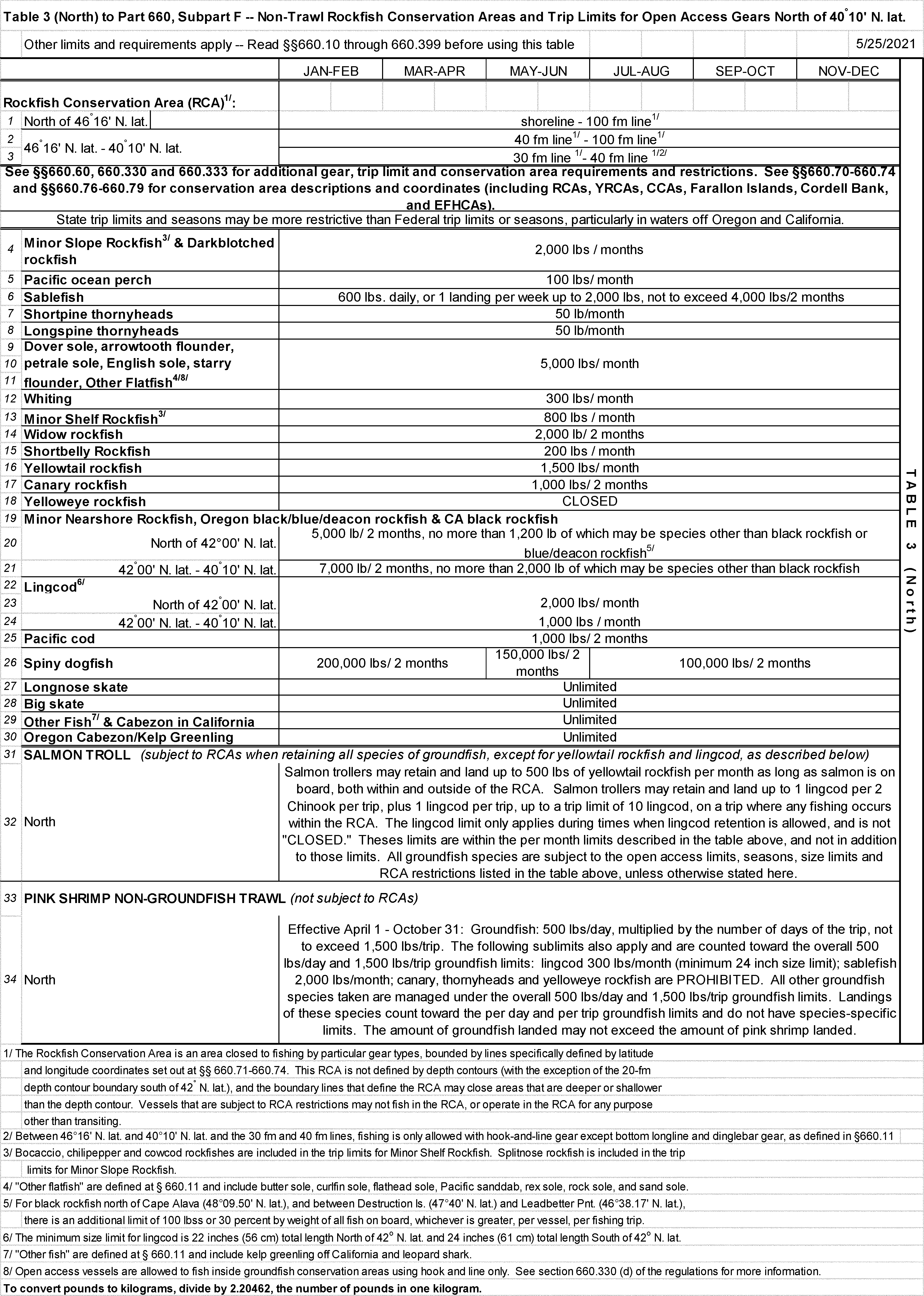
Table 3 (North) to Part 660, Subpart F - Non-Trawl Rockfish Conservation Areas and Trip Limits for Open Access Gears North of 40°10′ N. lat.
[86 FR 30553, June 9, 2021]
Table 3 (South) to Part 660, Subpart F - Non-Trawl Rockfish Conservation Areas and Trip Limits for Open Access Gears South of 40°10′ N. lat.


[85 FR 79923, Dec. 11, 2020; 86 FR 14384, Mar. 16, 2021; 86 FR 27821, May 24, 2021]